


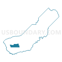
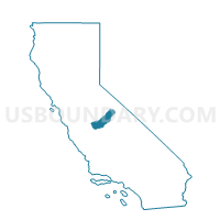
Voting District 20170, Madera County, California
About
Outline

Summary
| Unique Area Identifier | 534726 |
| Name | Voting District 20170 |
| County | Madera County |
| State | California |
| Area (square miles) | 51.78 |
| Land Area (square miles) | 51.78 |
| Water Area (square miles) | 0.00 |
| % of Land Area | 100.00 |
| % of Water Area | 0.00 |
| Latitude of the Internal Point | 36.95409390 |
| Longtitude of the Internal Point | -120.22514930 |
Maps

Graphs
Select a template below for downloading or customizing gragh for Voting District 20170, Madera County, California


Neighbors
Neighoring Voting District (by Name) Neighboring Voting District on the Map
- Voting District 10005, Madera County, CA
- Voting District 10020, Madera County, CA
- Voting District 10040, Madera County, CA
- Voting District 10095, Madera County, CA
- Voting District 20150, Madera County, CA
- Voting District 20165, Madera County, CA
- Voting District 20180, Madera County, CA
- Voting District 20185, Madera County, CA
- Voting District 20190, Madera County, CA
- Voting District 20250, Madera County, CA
- Voting District 30280, Madera County, CA
- Voting District 30290, Madera County, CA
- Voting District 30300, Madera County, CA
- Voting District 30305, Madera County, CA
- Voting District 30345, Madera County, CA
Top 10 Neighboring County Subdivision (by Population) Neighboring County Subdivision on the Map
- Madera CCD, Madera County, CA (92,437)
- Madera Southeast CCD, Madera County, CA (5,319)
- Madera West CCD, Madera County, CA (1,288)
Top 10 Neighboring Place (by Population) Neighboring Place on the Map
Top 10 Neighboring Elementary School District (by Population) Neighboring Elementary School District on the Map
Top 10 Neighboring Secondary School District (by Population) Neighboring Secondary School District on the Map
Top 10 Neighboring Unified School District (by Population) Neighboring Unified School District on the Map
- Madera Unified School District, CA (87,841)
- Firebaugh-Las Deltas Joint Unified School District, CA (8,557)
Top 10 Neighboring State Legislative District Lower Chamber (by Population) Neighboring State Legislative District Lower Chamber on the Map
Top 10 Neighboring State Legislative District Upper Chamber (by Population) Neighboring State Legislative District Upper Chamber on the Map
Top 10 Neighboring 111th Congressional District (by Population) Neighboring 111th Congressional District on the Map
Top 10 Neighboring Census Tract (by Population) Neighboring Census Tract on the Map
- Census Tract 7, Madera County, CA (10,776)
- Census Tract 5.03, Madera County, CA (8,539)
- Census Tract 10, Madera County, CA (5,319)
- Census Tract 4, Madera County, CA (1,288)